


Barton Voting District, George County, Mississippi
About
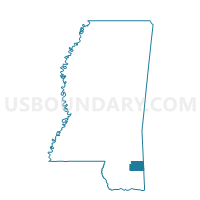
Outline

Summary
| Unique Area Identifier | 605386 |
| Name | Barton Voting District |
| County | George County |
| State | Mississippi |
| Area (square miles) | 19.97 |
| Land Area (square miles) | 19.83 |
| Water Area (square miles) | 0.14 |
| % of Land Area | 99.28 |
| % of Water Area | 0.72 |
| Latitude of the Internal Point | 30.75672820 |
| Longtitude of the Internal Point | -88.58966650 |
Maps


Graphs
Select a template below for downloading or customizing gragh for Barton Voting District, George County, Mississippi


Neighbors
Neighoring Voting District (by Name) Neighboring Voting District on the Map
- Agricola Voting District, George County, MS
- Basin School Voting District, George County, MS
- Broom School Voting District, George County, MS
- East Central Voting District, Jackson County, MS
- Movella Voting District, George County, MS
Top 10 Neighboring County Subdivision (by Population) Neighboring County Subdivision on the Map
- District 1, Jackson County, MS (28,313)
- District 2, George County, MS (5,003)
- District 3, George County, MS (4,739)
- District 5, George County, MS (3,904)
Top 10 Neighboring Unified School District (by Population) Neighboring Unified School District on the Map
Top 10 Neighboring State Legislative District Lower Chamber (by Population) Neighboring State Legislative District Lower Chamber on the Map
Top 10 Neighboring State Legislative District Upper Chamber (by Population) Neighboring State Legislative District Upper Chamber on the Map
Top 10 Neighboring 111th Congressional District (by Population) Neighboring 111th Congressional District on the Map
Top 10 Neighboring Census Tract (by Population) Neighboring Census Tract on the Map
- Census Tract 401.01, Jackson County, MS (7,158)
- Census Tract 9503.01, George County, MS (6,450)
- Census Tract 9501.01, George County, MS (5,783)